
Hornet Nest
Localization Platform
Turning field observations and geospatial data into more effective hornet nest searches.
Client profile
The client set out to develop a specialized digital platform supporting beekeepers and professionals involved in locating Asian hornet nests.
Asian hornets pose a serious threat to bee populations and local ecosystems. However, identifying the location of a nest is often a time-consuming field process that depends heavily on expert knowledge, repeated observations, and manual interpretation of flight directions.
The client required a practical geospatial tool that could support field teams, organize observation data, and improve decision-making during nest localization activities.
Challenge
Locating Asian hornet nests requires specialists to observe individual insects, record their positions, estimate flight directions, and determine where multiple observation paths are likely to intersect.
Without a dedicated digital system, this process can be difficult to coordinate, visualize, and verify.
The client needed a solution capable of:
- Recording geolocated field observations
- Capturing hornet flight directions
- Calculating potential nest locations
- Visualizing search areas on an interactive map
- Suggesting additional observation points
- Managing multiple localization projects
- Sharing projects with field users
- Supporting navigation to relevant locations
- Exporting collected data for further analysis
The goal was not to replace the expertise of field professionals, but to provide them with a structured decision-support system that could make nest searches more accurate, repeatable, and efficient.
Our Strategic Approach
We approached HIVE FIVE as a geospatial field operations platform rather than a standard mapping application.
The solution needed to combine geographic data, mathematical triangulation models, interactive visualization, and practical field workflows within a single intuitive web interface.
Our work focused on four key areas:
- Translating complex triangulation calculations into an accessible user experience
- Enabling structured collection and management of field observations
- Delivering high-performance geospatial visualization
- Building an architecture ready for future analytical and AI-based capabilities
The first increment was developed within a limited budget and MVP scope, with emphasis placed on validating the core localization process in real field conditions.
From Manual Field Analysis to a Geospatial Nest Localization Platform
We developed a web-based GIS application that helps field specialists collect observations, calculate potential nest locations, and coordinate search activities.
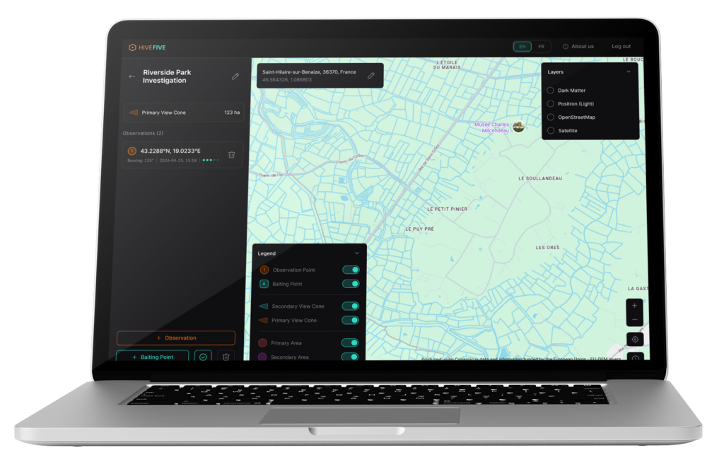
Geolocated Field Observations
Users can register observation points directly within individual localization projects. Each observation can include geographic coordinates and relevant field information, creating a structured dataset that can be analyzed and visualized throughout the search process.
Flight Direction Recording
The platform allows users to enter the observed flight direction, or bearing, of individual hornets. These directional measurements form the foundation of the triangulation model and help determine the probable direction of the nest from each observation point.
Automated Nest Location Triangulation
A dedicated calculation engine processes geolocation data and recorded flight directions to estimate the potential location of a hornet nest. By combining multiple observations, the system helps users identify areas where flight paths intersect and where further field investigation should be concentrated.
Interactive Search Area Visualization
Potential nest locations, observation points, flight directions, and analytical search areas are displayed through an interactive map powered by MapLibre. This transforms complex spatial calculations into a visual format that can be easily interpreted by field users.
Suggested Observation Points
Based on the available observation data, the application can support users in selecting additional observation locations. This helps specialists plan the next stage of the search and collect the information needed to narrow down the potential nest area.
Project Sharing and Field Navigation
Localization projects can be shared with people operating in the field. Users can access relevant observation data and navigate toward locations where hornets have been detected, improving coordination between experts and field teams.
Geospatial Data Export
Project and observation data can be exported for further analysis, reporting, or validation outside the application. This allows the client to examine real-world test results and continue refining the triangulation methodology.
High-Performance Map Delivery
To ensure smooth map interactions, we implemented a dedicated geospatial data delivery architecture using Martin Tile Server. Map layers and analytical areas are served efficiently without placing unnecessary load on the main application layer. Caching mechanisms further reduce repeated requests to external map providers, improving application performance and limiting infrastructure overhead.
Hive Five Tech Stack
To deliver accurate geospatial calculations and responsive field visualization, we combined modern GIS technologies with a scalable data architecture.
- Mapping Interface: MapLibre
- Geospatial Database: PostgreSQL with PostGIS
- Map Data Delivery: Martin Tile Server
- Core Product: Web-Based GIS Application
- Key Calculation Component: Geospatial Triangulation Engine
- Infrastructure: Automated CI/CD Pipeline
The architecture separates geospatial data delivery from the primary application layer, improving performance and preparing the platform for future integrations with environmental data, weather information, and AI-based analysis.
Results
The project resulted in the first functional version of a dedicated hornet nest localization platform ready for field testing.
The client received a web-based tool capable of collecting real observation data, visualizing flight directions, calculating potential nest locations, and supporting teams during field searches.
The application also allows the client to validate the effectiveness of the triangulation model, collect feedback from specialists, and establish a technical foundation for the next stages of product development.
Operational Outcomes
- Functional GIS platform ready for field testing
- Structured collection of geolocated observations
- Recording and visualization of hornet flight directions
- Automated triangulation of potential nest locations
- Interactive visualization of search areas
- Suggestions for additional observation points
- Project sharing with field users
- Navigation to relevant observation locations
- Export of project data for further analysis
- Efficient geospatial layer delivery and caching
- Multilingual architecture prepared for expansion
Strategic Impact
Hive Five transformed a specialist field process into a structured and testable digital workflow.
The solution delivered:
- More consistent management of field observations
- Faster interpretation of geographic and directional data
- Better coordination between experts and field teams
- A visual decision-support tool for planning search activities
- A practical environment for validating the triangulation model
- Reduced reliance on fragmented notes and manual map analysis
- A scalable foundation for future product development
The architecture was also prepared for potential extensions involving artificial intelligence, weather information, environmental layers, and more advanced geospatial analysis.
Most importantly, the platform enabled the client to move from a theoretical localization concept to a working field tool that can be tested using real observations and continuously improved based on practical search results.
Let’s build your
product together!
We shorten the time from problem to solution, which is why we focus on agile communication and action. We like to get straight to the point, so let’s schedule a free 20-minute consultation. No forms, no waiting.
Speak directly with Radek Lejsza, COO of Codeflyers

What our clients says about outcome of the collaboration?
We sent this question directly to our partners
Working with Codeflyers has been a game-changer for us! Their innovative approach and unparalleled technical expertise have propelled our project to new heights. We’re thrilled with the progress and their proactive attitude.
Christoffer Apneseth
CTO at Field
Our collaboration with Codeflyers is a perfect match! Their team is not only competent but also incredibly dedicated. The application is growing stronger, all thanks to their commitment and attention to detail.
Even Reitan
Strategy & Business Development Manager at Telenor